
561 Warrigal Road
Ashwood, 3147 VIC
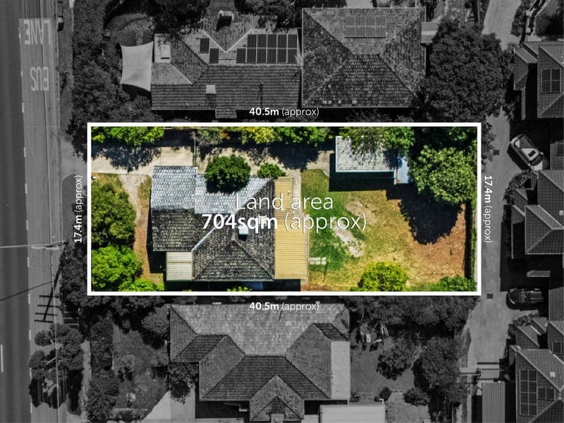
1975 house on a 704 m² block with 17m frontage.
Property Snapshot
1975House3 Bed1 Bath2 Off Street704 m² Land137 m² Internal17m Frontage
Investment Highlights
What makes 561 Warrigal Road compelling from a buying and value-add perspective.
Market Status
Off Market
Land Size
704 m²
Frontage
17m
Zoning
GRZ3
Residential - Medium Density
Why Buyers Look At This One
Rare add-value profile — 1975 house on a 704 m² block and a 17m frontage.
Renovate upside — modest 137 m² internal area creates a clear renovation, extension or reconfiguration opportunity.
Walkable transport position — approx. 135m to bus, 834m to train station and 952m to schools.
Neighbourhood quality — strong owner occupier setting with low-turnover character housing nearby.
Property Snapshot
Core facts, planning controls and ownership history.
Bedrooms
3
Bathrooms
1
Parking
2 off-street
Internal Area
137 m²
Ownership & Value
Last Sold$1.06M
Sold DateApr 2026
Land Value—
RPD1\TP184878
Planning & Site
Property TypeResidential
AccessSingle Access
Height Limit—
Max Storeys—
Wide FrontageResidential
Pricing & Valuation
Guide, estimate and broader pricing context.
Price Estimate
$1.06M
VeryHigh Confidence
Suburb Median
$1.28M
House (3 Beds)
Tenure
0 Years
Since 2026
Capital Gain
—
Since 2026
Suburb Sale Price Median - House (3 Beds)
Rental Market
Yield, rental pricing and local leasing landscape.
Suburb Median
$750 Pw
House (3 Beds)
Rental Yield
3.0%
House (3 Beds)
Vacancy Rate
1.7%
House (3 Beds)
Rentals Last 12M
63
House (3 Beds)
Suburb Rental Price Median - House (3 Beds)
Planning & Risk Overlays
Important due diligence considerations for this property.
Flood Overlay Detected
No flooding known in this area
Other Overlays
Bushfire: No bushfire known in this area. Heritage: No heritage known in this area. Biodiversity: VPO - VEGETATION PROTECTION OVERLAY - SCHEDULE 1.
Location & Connectivity
Access to transport, schools and local amenity around 561 Warrigal Road.
Train Station
834m
Bus Stop
135m
Schools
952m
Road Type
trunk
Transport: Easy access to nearby train station and frequent bus routes.
Lifestyle: Walking distance to local shops, parks and nearby dining precincts.
Positioning: Quiet residential street with strong owner occupier presence and limited turnover.
Neighbourhood Profile
Proximity to amenities and local context impacting livability.
Social Housing
0.0%Train Station
834mBus Stop
135mCentre Zone
93mRoad Type
trunk (High Noise)School Catchment
952mAshwood Snapshot
Broader suburb metrics that support the local story.
Population
7,154
Owner Occupiers
60%
Social Housing
0%
Crime Index
—
Not available
High Owner Occupier AppealLow Stock on MarketLow Vacancy
Explore Ashwood in more detail
Deep dive into growth, demand, demographics and comparable sales.
View Suburb Profile


